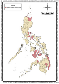
 A project funded by the Philippine Council for Agriculture, Aquatic and Natural Resources Research and Development of the Department of Science and Technology (DOST-PCAARRD) has identified 14 locations measuring a total of 6,283.30 hectares as potential sites for mussel culture. This was a result of a project that aimed to increase mussel production through identifying potential sites for mussel culture in the country.
The project, “Suitability assessment and database development for enhanced mussel culture management using geospatial technologies,” is being implemented by the University of the Philippines Visayas (UPV) and UP Diliman, under the leadership of Dr. Carlos C. Baylon of UPV, Miagao, Iloilo.
The project aims to identify potential sites that favor the hydrographic and biophysical conditions for mussel growth. Identification of suitable and potential areas for mussel culture could provide area for expansion of mussel culture leading to an increased mussel production. Additional mussel-growing areas can then lead to a more sustainable mussel industry which can help in addressing national issues like food security, livelihood and poverty alleviation.
Using geospatial technologies, 14 sites were identified, which include Hagnaya, Cebu (122 ha); Calape, Bohol (680 ha); Misamis Occidental particularly in Murcielagos and Panguil Bay (512.50 ha); Placer, Surigao del Norte (71.5 ha); Sagay, Negros Occidental (1,390 ha); Bais, Negros Oriental (1,300); Marinduque (1,098 ha); Buguey, Cagayan (34.3ha); Davao in Mati City and Panabo (990 ha); and Bislig, Surigao del Sur (100 ha). These are being validated by overlaying other information such as road accessibility, navigational lane, presence of corals and sea grasses, red tide history, source of spats, pollution, and tourism. As such, these sites can be utilized as expansion areas for green mussel culture to increase production in the Philippines.
 Available satellite data from the National Aeronautics and Space Administration (NASA) and European Space Agency (ESA) have been used to develop models for identifying suitable sites. Water parameters such as temperature, pH, dissolved oxygen, salinity, and chlorophyll A were collected from representative areas in the country. The criteria were also set to serve as basis for classification of sites. Using the data gathered, maps were created showing the different parameters and specific areas suitable for mussel culture.
To make the information accessible, the data gathered will then be incorporated in a database and will soon be posted online through an interactive website for the use of mussel farmers/growers, local government officials, and private individuals.
